Australia’s average population density is roughly 3.6 people per square kilometer, one of the lowest figures of any country on earth. Mongolia is emptier. Namibia is emptier. But almost nowhere else with that kind of average density also contains a city where 8,100 people are packed into a single square kilometer, as inner Sydney recorded back in 2006. The national average hides one of the most extreme population distributions on the planet, and that gap between the average and the reality is the real story.
Australia Has a Low Average Density, But That Doesn’t Tell the Whole Story
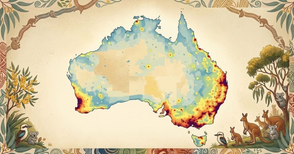
A country the size of the contiguous United States, minus Alaska, holds a population smaller than Texas and California combined. Spread evenly, Australia’s 27.8 million people would leave most of the continent almost empty. In practice, they don’t spread evenly at all. Roughly 87% of Australians live in urban areas, and most of those urban Australians live within 50 kilometers of the coast, leaving the country’s vast interior among the most sparsely populated inhabited landmasses on earth.
What Population Density Means
Population density is calculated with a simple formula:
Population density = Population ÷ Land area
For Australia, that means approximately 27.8 million people divided across a land area of roughly 7.69 million square kilometers, producing a national average of about 3.6 people per square kilometer. The figure is useful as a baseline, but for a country with Australia’s settlement pattern, the average is close to meaningless on its own. It needs to be read alongside where that population is actually concentrated.
Australia’s Population Density at a Glance
| Metric | Figure |
|---|---|
| Total population (Dec 2025) | 27,801,023 |
| Total land area | ~7.69 million km² |
| National average density | ~3.6 people/km² |
| Urban population share | ~87% |
| Density, 2005 | 2.6 people/km² |
| Density, 2006 | 2.7 people/km² |
| Density growth, 2005-2025 | +38% |
Australia’s average density has risen by roughly 40% over the past two decades, even though the physical land area obviously has not changed. All of that increase reflects population growth layered onto an already concentrated settlement pattern.
Density by State and Territory
| Rank | State/Territory | Approx. population (2025) | Land area (km²) | Approx. density (people/km²) |
|---|---|---|---|---|
| 1 | Australian Capital Territory | ~470,000 | 2,358 | ~199 |
| 2 | Victoria | ~7.12 million | 227,444 | ~31.3 |
| 3 | New South Wales | ~8.64 million | 800,642 | ~10.8 |
| 4 | Tasmania | ~570,000 | 68,401 | ~8.3 |
| 5 | Queensland | ~5.71 million | 1,729,742 | ~3.3 |
| 6 | South Australia | ~1.9 million | 983,482 | ~1.9 |
| 7 | Western Australia | ~3.0 million | 2,527,013 | ~1.2 |
| 8 | Northern Territory | ~255,000 | 1,419,630 | ~0.18 |
The Australian Capital Territory has held the title of most densely populated jurisdiction for decades, because Canberra effectively is the territory, leaving almost no low-density rural land to drag the average down. The Northern Territory sits at the opposite extreme, with a density roughly 1,000 times lower than the ACT, a gap almost unmatched anywhere else in the developed world within a single federated nation.
Australia’s Most Densely Populated Urban Areas
At the suburb level, Australia’s density figures rival anywhere in the world. In 2006, Sydney’s inner-city areas recorded the highest densities in the country: Sydney East at 8,100 people per square kilometer, Sydney West at 7,200, and Waverley, covering the beachside suburbs of Coogee, Bronte and Bondi, at 6,900. Melbourne’s inner core followed close behind at 6,600 people per square kilometer, then the fourth-highest in the nation, with Port Phillip-St Kilda close behind. Since then, apartment construction booms in inner Sydney, inner Melbourne and inner Brisbane have pushed several precincts well past those 2006 levels, particularly around the Sydney CBD, Melbourne’s Docklands and Southbank, and Brisbane’s inner south.
Australia’s Population Concentration Along the Coast
The overwhelming majority of Australians live within a narrow coastal band, concentrated in two distinct regions: the south-east and east coast running from Adelaide through Melbourne, Canberra, Sydney and Brisbane, and a smaller south-west pocket centered on Perth. This pattern developed for reasons that are still largely unchanged today. Reliable water and arable land are concentrated near the coast.
Historical settlement, driven by colonial-era ports, established the country’s largest cities where ships could dock. Employment, infrastructure and services have compounded around those same population centers for more than two centuries, creating a feedback loop that continues to draw new residents and migrants toward the same coastal corridors rather than the interior.
Australia’s Interior: Why Is Population So Sparse?
Australia’s interior remains sparsely populated for a combination of climate, water and economic reasons rather than any lack of land. Much of the continent’s center and west is arid or semi-arid, with rainfall too unreliable to support large-scale agriculture or dense settlement without significant infrastructure investment. Water availability, rather than land availability, is the binding constraint across most of the interior.
Agricultural limitations follow directly from that: much of the interior can support only low-intensity grazing rather than the higher-yield farming that sustains denser rural populations elsewhere in the world. Distance compounds every other factor, since low population density makes infrastructure like roads, rail, healthcare and telecommunications dramatically more expensive per resident to provide, which in turn discourages further settlement, a self-reinforcing cycle that has held the Northern Territory’s density below 0.2 people per square kilometer for decades.
Capital Cities vs Regional Australia
Capital cities house close to two-thirds of Australia’s total population, and the imbalance is sharpest in the smaller states. South Australia and Western Australia in particular have a single dominant capital, Adelaide and Perth respectively, that vastly outweighs the rest of the state in both population and density. New South Wales and Victoria have somewhat more developed regional centers, but Sydney and Melbourne still anchor the overwhelming majority of state population growth.
Regional Australia, by contrast, has experienced uneven fortunes: some coastal and lifestyle regional centers have grown quickly, particularly since the pandemic-era shift toward remote work, while many inland agricultural and mining towns have continued to lose population to the capitals.
Population Density Over Time
Australia’s national density has climbed steadily and predictably: 2.5 people per square kilometer in 2001, 2.6 in 2005, 2.7 in 2006, and roughly 3.6 by 2025. That trajectory tracks almost exactly with total population growth, since Australia’s land area is fixed and its settlement pattern, concentrated along the coast, has not meaningfully changed direction in over a century. What has changed is the intensity of development within that same settled footprint, with inner-city apartment density rising far faster than the national average as capital cities absorb a growing share of total population growth.
Density Within Australia’s Major Cities
Within any major Australian city, density falls off sharply moving outward from the center. Inner-city areas, dominated by apartments and townhouses, now reach several thousand people per square kilometer in Sydney, Melbourne and Brisbane. Established middle suburbs typically sit in the low hundreds to low thousands per square kilometer, reflecting a mix of medium and low-density housing.
Outer suburbs and newer growth corridors, built predominantly on detached housing on larger blocks, often fall below 1,000 people per square kilometer despite housing large and rapidly growing populations in absolute terms.
Fastest-Densifying Areas
The fastest increases in density are occurring in two very different types of location. Inner-city apartment precincts in Sydney, Melbourne and Brisbane have seen the sharpest rises as high-rise development has intensified over the past 15 years.
At the same time, outer growth corridors on the fringes of Melbourne, Sydney and south-east Queensland are adding population faster than almost anywhere else in the country in absolute terms, even though their density per square kilometer remains comparatively low, because they are converting agricultural and semi-rural land into new housing estates at scale.
Australia’s Future Density
By 2030, continued growth concentrated in the existing coastal corridor is expected to push capital city densities higher still, particularly in inner and middle-ring suburbs where planning policy increasingly favors medium and high-density infill over further outward sprawl.
By 2050, under the Centre for Population’s baseline projections that place Australia’s population between roughly 33 and 34 million, national average density would rise to somewhere near 4.3 to 4.5 people per square kilometer, still extraordinarily low by global standards but concentrated ever more tightly into the same handful of urban regions that have anchored Australian settlement since Federation.
New housing supply, urban infill policy and the pace of regional growth will determine how much of that additional population is absorbed through greater density in existing footprints versus further outward urban expansion.
Density and Infrastructure
- Roads: Outer growth corridors consistently face the largest gap between population growth and road capacity, since transport infrastructure lags residential construction
- Public transport: Higher-density inner and middle suburbs support more viable public transport investment, while low-density outer suburbs remain heavily car-dependent
- Housing: Rising inner-city density has been driven largely by apartment supply, while outer-suburb growth continues to rely on detached housing on the urban fringe
- Schools: Fast-growing outer suburbs regularly outstrip planned school capacity years ahead of infrastructure funding cycles
- Hospitals: Health infrastructure planning in low-density regional and remote areas must contend with far higher per-resident servicing costs than in dense metropolitan areas
- Utilities: Water, sewerage and energy networks in outer growth corridors face the steepest capital costs per new resident connected
Density vs Liveability
Higher density is not automatically better or worse than lower density; the relationship with liveability depends heavily on how well infrastructure keeps pace with population growth. Well-planned high-density inner-city living can deliver strong access to public transport, employment and services. Poorly planned high-density growth, without matching investment in transport, schools and green space, can produce overcrowding and strained infrastructure.
Similarly, low-density outer-suburban and regional living can offer more space and affordability, but often at the cost of longer commutes and weaker access to services. Australia’s ongoing density debate, playing out most visibly in Sydney and Melbourne planning policy, centers on exactly this trade-off between infill density and outward expansion.
Key Findings
- Australia’s national population density is approximately 3.6 people per square kilometer, up roughly 40% since 2005
- The Australian Capital Territory is the most densely populated jurisdiction at around 199 people per square kilometer; the Northern Territory is the least dense at around 0.18
- Inner Sydney recorded Australia’s highest recorded suburb-level densities historically, at 8,100 people per square kilometer in Sydney East in 2006, with several precincts now exceeding that figure
- Around 87% of Australians live in urban areas, overwhelmingly concentrated along the south-east, east and south-west coasts
- Water availability, not land availability, is the primary constraint limiting settlement across Australia’s interior
- By 2050, national average density is projected to rise to roughly 4.3 to 4.5 people per square kilometer under baseline population projections
Frequently Asked Questions
1. What is Australia’s population density?
Approximately 3.6 people per square kilometer nationally, one of the lowest average densities of any country in the world.
2. Why is Australia’s population density so low if its cities are crowded?
Because the national average spreads 27.8 million people across roughly 7.69 million square kilometers of land, most of which is sparsely populated interior, while the population itself is heavily concentrated in a small number of coastal cities.
3. Which Australian state or territory has the highest population density?
The Australian Capital Territory, at roughly 199 people per square kilometer, because Canberra makes up almost the entire territory.
4. Which state or territory has the lowest population density?
The Northern Territory, at roughly 0.18 people per square kilometer, reflecting its vast arid interior and smaller population.
5. Why do most Australians live near the coast?
Because reliable water and arable land, historical port-based settlement, and concentrated employment and infrastructure have all reinforced coastal population growth since colonization.
6. What is the most densely populated suburb or area in Australia?
Inner Sydney precincts have historically recorded the country’s highest densities, with Sydney East reaching 8,100 people per square kilometer in 2006, a figure several inner-city precincts have since surpassed.
7. Is Australia’s population density increasing?
Yes. National average density rose from around 2.5 people per square kilometer in 2001 to roughly 3.6 by 2025, and is projected to keep rising as population growth continues within the same land area.
8. What percentage of Australians live in urban areas?
Approximately 87% of Australians live in urban areas as of the mid-2020s.
9. Why is Australia’s interior so sparsely populated?
Primarily due to arid and semi-arid climate, limited and unreliable water supply, restricted agricultural potential, and the high cost of infrastructure across vast distances.
10. What will Australia’s population density look like by 2050?
Under baseline population projections of around 33 to 34 million people, national average density would rise to approximately 4.3 to 4.5 people per square kilometer, still concentrated overwhelmingly in existing coastal urban regions.
Sources
- Australian Bureau of Statistics, Geographic Distribution of the Population (historical releases, 2005 and 2006)
- Australian Bureau of Statistics, National, State and Territory Population, December 2025
- Worldometer, Australia Population, elaboration of UN World Population Prospects 2024 Revision
- Centre for Population, 2025 Population Snapshot
- geocountries.com, Australia States and Provinces Ranked by Population Density, 2026