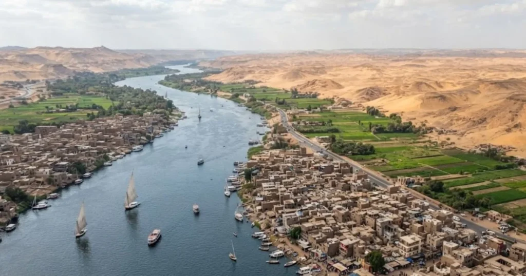
Egypt’s population reached about 107.5 million as of January 2026, according to CAPMAS-based estimates, and more than 95 percent live on less than 5 percent of the country’s land area: the narrow ribbon of the Nile Valley and the fan-shaped Nile Delta. The remaining 95-plus percent of Egypt’s roughly 1.01 million square kilometers is largely uninhabited desert.
That means Egypt’s national population density of around 108 to 121 people per square kilometer, depending on the estimate used, is close to meaningless as a description of how Egyptians actually live, since the real density within the inhabited Nile corridor runs many multiples higher, reaching roughly 40,000 people per square kilometer in parts of Cairo. Few countries anywhere illustrate the difference between a population’s total number and its lived geography as starkly as Egypt does.
Egypt’s Population Is Highly Concentrated
Egypt’s inhabited land area covers only about 105,200 square kilometers, roughly 10.5 percent of the country’s total 1.01 million square kilometers by one Statista-cited estimate, though other sources place the truly densely settled corridor closer to 5 percent when limited strictly to the Nile Valley, Delta and immediate outlying cities like Alexandria and Port Said.
El Wadi El Gedid, the New Valley governorate covering the bulk of Egypt’s Western Desert, illustrates the contrast starkly: at 440,098 square kilometers, it is Egypt’s largest governorate by a wide margin, covering roughly 42.3 percent of the entire country, yet it held just 270,854 residents as of January 2024, a population density of only 0.6 people per square kilometer.
Egypt Population at a Glance
| Metric | Figure | Year |
|---|---|---|
| National population | ~107.5 million | January 2026 |
| Share of population in Nile Valley/Delta | 95%+ | current |
| Share of land area inhabited | ~5-10.5% | current |
| National average density | ~108-121/km² | 2025-2026 |
| Cairo Governorate density | 3,308-5,610/km² | 2023-2025 |
| New Valley Governorate density | 0.6/km² | 2024 |
| Annual population growth | ~1.5-1.6 million net | 2026 |
Why the Nile Determines Egypt’s Population Geography
Egypt’s population geography follows water, not political boundaries or economic zoning. The Nile River and its delta provide nearly all of Egypt’s fresh water and fertile agricultural land, meaning settlement outside the river corridor has historically required either oasis access, as in the isolated communities of the Western Desert, or, more recently, substantial state investment in desalination, groundwater extraction or Nile water diversion projects.
This dependency traces back millennia: Egyptian civilization itself developed along the Nile precisely because the river’s seasonal flooding made settled agriculture possible in what would otherwise be uninhabitable desert, and that ancient settlement logic still governs where the overwhelming majority of Egypt’s 107.5 million residents live today.
The Nile Valley and Delta Are Egypt’s Main Population Zones
Egypt’s inhabited territory divides into two connected but geographically distinct zones. Upper Egypt follows the narrow Nile Valley corridor south of Cairo, where the river cuts through desert on both sides, producing a population distribution that hugs the riverbanks in a long, thin ribbon rarely more than a few kilometers wide.
Lower Egypt encompasses the Nile Delta north of Cairo, where the river fans out into a much broader, triangular expanse of fertile land before reaching the Mediterranean, supporting a considerably wider and more agriculturally productive settlement zone than the narrow Upper Egypt valley.
Together, these two zones, plus the immediately outlying coastal cities of Alexandria and Port Said, account for the more than 95 percent of Egypt’s population that CAPMAS and international sources consistently identify as living within this Nile-dependent corridor.
Cairo Is the Country’s Major Population Center
Cairo anchors Egypt’s population geography as both the country’s and the African continent’s largest city. Cairo Governorate itself held approximately 10.2 million residents as of January 2023, at a density of roughly 3,308 to 5,610 people per square kilometer depending on the source and measurement year, while the broader Greater Cairo metropolitan area, encompassing Cairo, Giza and surrounding satellite cities including the New Administrative Capital, reached an estimated 22.18 million residents by 2023, up from 20.5 million in 2012. That places Greater Cairo among the largest urban agglomerations in the world and, by a wide margin, the largest in Africa or the Arab world.
Egypt’s Largest Cities and Metropolitan Areas
| City/Metro Area | Population | Year |
|---|---|---|
| Greater Cairo (metro) | 22.18 million | 2023 |
| Cairo (governorate) | 10.2-10.4 million | 2023-2025 |
| Giza (governorate) | 9.8 million | 2025 |
| Alexandria | ~5.3 million | current |
Population Density Is Extremely Uneven
The gap between Egypt’s national average density and its actual lived density illustrates why national density figures can be profoundly misleading in a country like Egypt. While Egypt’s overall national density sits somewhere around 108 to 121 people per square kilometer depending on the source, INED research places Cairo’s actual density at approximately 40,000 inhabitants per square kilometer as of a 2006 estimate, and Giza’s at roughly 5,300, figures that dwarf the density of most major cities in North America or Europe.
At the opposite extreme, South Sinai governorate, a tourism-oriented Red Sea coastal region, held a mere 120,000 residents as of the most recent Statista-cited estimate, while the vast New Valley governorate held just 270,854 people across 440,098 square kilometers, a density of 0.6 per square kilometer, effectively empty by any conventional standard.
Egypt’s New Cities and Desert Development Strategy
Egypt has pursued a sustained, decades-long strategy of attempting to redistribute population away from the overcrowded Nile corridor through planned desert city development. The most prominent recent example is the New Administrative Capital, a purpose-built city constructed east of Cairo specifically to relieve the Egyptian capital’s crushing congestion and to relocate government functions and eventually substantial residential population away from the traditional Nile-adjacent urban core.
This follows earlier waves of planned satellite city development around Cairo, including 6th of October City and New Cairo, both now integrated into the Greater Cairo metropolitan area’s broader footprint as the city has expanded outward from its historic Nile-bound center into the surrounding desert margins, aided by infrastructure investment specifically designed to make desert settlement viable.
Urbanization and Metropolitan Expansion
Cairo’s growth from a metropolitan population of 20.5 million in 2012 to 22.18 million by 2023 illustrates the continued pull of Egypt’s capital even as government policy has actively tried to redirect some of that growth toward new desert satellite cities.
Alexandria, Egypt’s second-largest city and principal Mediterranean port, with roughly 5.3 million residents, and Giza, which blends seamlessly into the Greater Cairo metropolitan footprint despite being officially a separate city, round out Egypt’s tier of major urban centers, together anchoring the country’s economic and cultural life within the same narrow Nile-adjacent corridor that has defined Egyptian settlement for millennia.
Population Growth Is Increasing Pressure on Land and Water
Egypt adds approximately 1.5 to 2 million net residents annually as of 2026 estimates, though this pace has slowed from peaks above 2 million per year in earlier periods, reflecting fertility that remains above replacement level even as it has gradually declined, combined with continued mortality improvements and limited net emigration.
Egypt’s median age of approximately 24.5 years reflects this continued, if moderating, population growth. That growth, concentrated overwhelmingly within the already-crowded Nile Valley and Delta given the practical limits on desert settlement even with the New Administrative Capital and similar projects, has intensified long-standing concerns about water security, particularly given Egypt’s near-total dependence on the Nile for both agricultural and municipal water needs, concerns that have grown more acute alongside anxieties tied to upstream dam construction affecting the river’s flow into Egyptian territory.
Egypt already imports a substantial share of its wheat consumption, a dependency that reflects the practical limits of expanding agricultural land within a country where over 95 percent of arable land already sits within the narrow, increasingly built-up Nile corridor.
Egypt’s Future Population Geography
Egypt’s population is projected to climb toward approximately 160 million by 2050, according to trend-based projections building on the country’s roughly 1.5 to 1.6 percent current annual growth rate, continuing a trajectory that has seen the population expand from approximately 21 million in 1950, nearly quintupling over seven decades.
Whether that continued growth further intensifies concentration within the already-strained Nile Valley and Delta, or whether desert development strategies like the New Administrative Capital succeed in meaningfully redistributing population toward new urban centers, will substantially shape Egypt’s water security, agricultural capacity and urban infrastructure planning for decades to come, given that the fundamental geographic constraint, a country that is over 95 percent desert with population access to fresh water confined almost entirely to one river system, is not something government policy can change, only work around.
Conclusion
Egypt’s population statistics only make sense once the country’s fundamental geographic constraint is accounted for: a nation that is over 95 percent desert, with virtually its entire population, agriculture and urban economy compressed into a narrow river corridor covering a small fraction of the total land area. That compression has produced some of the highest local population densities on Earth in parts of Cairo, alongside vast, nearly empty desert governorates like New Valley.
Egypt’s continued population growth toward a projected 160 million by 2050, combined with sustained government efforts to redirect settlement toward new desert cities, means the tension between where Egyptians live and where Egypt’s land actually is will remain a defining feature of the country’s development for decades to come.
Key Findings
- Egypt’s population reached approximately 107.5 million as of January 2026, with more than 95 percent living within the Nile Valley and Delta, less than 5 to 10.5 percent of the country’s total land area.
- Cairo’s actual population density reaches approximately 40,000 people per square kilometer in parts of the city, dwarfing Egypt’s national average density of roughly 108 to 121 per square kilometer.
- Greater Cairo’s metropolitan population reached an estimated 22.18 million by 2023, up from 20.5 million in 2012, making it Africa’s largest urban agglomeration.
- The New Valley governorate, covering 42.3 percent of Egypt’s total land area, held just 270,854 residents as of January 2024, a density of only 0.6 people per square kilometer.
- Egypt adds approximately 1.5 to 2 million net residents annually, with the population projected to climb toward 160 million by 2050.
- Egypt’s government has pursued sustained desert city development, most recently the New Administrative Capital, aimed at redistributing population away from the congested Nile corridor.
Frequently Asked Questions
1. Why does Egypt’s population live along the Nile?
The Nile River and its delta provide nearly all of Egypt’s fresh water and fertile agricultural land in an otherwise desert country, a dependency dating back to ancient Egyptian civilization that continues to concentrate over 95 percent of the modern population within the narrow river corridor.
2. What percentage of Egypt’s population lives in the Nile Valley and Delta?
More than 95 percent of Egypt’s population lives within the Nile Valley, Delta and immediately outlying cities such as Alexandria and Port Said, according to consistent estimates from CAPMAS and international demographic sources, despite this area covering less than 5 to 10.5 percent of the country’s total land.
3. Is Egypt trying to redistribute its population?
Yes. Egypt has pursued decades of planned desert city development, including 6th of October City, New Cairo and, most recently, the New Administrative Capital east of Cairo, specifically aimed at relieving congestion in the traditional Nile-adjacent urban core.
4. What is Egypt’s total population?
Egypt’s population reached approximately 107.5 million as of January 2026 according to CAPMAS-based estimates, with other international sources placing recent estimates in a broadly similar range around 108 to 120 million depending on methodology and reference date.
5. How big is Cairo?
Cairo Governorate held approximately 10.2 to 10.4 million residents as of recent estimates, while the broader Greater Cairo metropolitan area, including Giza and surrounding satellite cities, reached an estimated 22.18 million by 2023.
6. Why is Egypt’s national population density figure misleading?
Egypt’s national average density of roughly 108 to 121 people per square kilometer averages across a country that is over 90 percent uninhabited desert, obscuring the fact that actual density within the inhabited Nile corridor, including parts of Cairo, reaches approximately 40,000 people per square kilometer.
7. What is Egypt’s least populated area?
South Sinai governorate held a mere 120,000 residents as of recent estimates, while the vast New Valley governorate, covering 42.3 percent of Egypt’s total land area, held just 270,854 people, a density of 0.6 per square kilometer.
8. How fast is Egypt’s population growing?
Egypt adds approximately 1.5 to 2 million net residents annually as of 2026 estimates, a pace that has moderated from earlier peaks above 2 million per year but still reflects fertility above replacement level.
9. What is Egypt’s population projected to reach by 2050?
Trend-based projections suggest Egypt’s population could climb toward approximately 160 million by 2050, continuing the growth trajectory that has seen the population nearly quintuple from about 21 million in 1950.
10. Why does Egypt import so much wheat despite being a major agricultural country historically?
Because over 95 percent of Egypt’s arable land already sits within the narrow, increasingly built-up Nile corridor, there is limited room to expand agricultural production to match continued population growth, a constraint that has pushed Egypt to import a substantial share of its wheat consumption even as it works to maximize productivity on existing farmland.
Sources
- Statista, “Egypt: total population by governorate 2025”
- Institut National d’Études Démographiques (INED), “Egypt, an exception in its geographical region”
- Wikipedia/Cairo Governorate, Wikipedia/New Valley Governorate, Wikipedia/Greater Cairo
- Geography Worlds, “Population of Egypt (2025): Size, Growth & Demographics”
- World Population Review, “Egypt Population 2026”
- WorldPopulationClock.net, “Egypt Population 2026,” CAPMAS and UN World Population Prospects 2024-based estimates