
Russia spans over 17 million square kilometers and holds approximately 144 million people. Bangladesh occupies a territory roughly the size of Iowa and is home to nearly 170 million. By sheer headcount, Russia appears to be the larger demographic story.
Yet Bangladesh is one of the most densely populated nations on earth, with over 1,200 people per square kilometer, while Russia averages fewer than 9. Those two numbers tell entirely different stories about land use, infrastructure pressure, public health capacity, and the daily lived reality of citizens in each country.
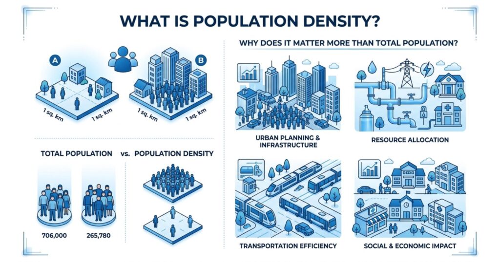
Population density, the number of people per unit of land area, typically expressed as persons per square kilometer or square mile, is one of the most consequential metrics in geography, urban planning, economics, and public policy. It transforms the raw figure of total population into something far more revealing: a picture of how concentrated or dispersed human settlement actually is. Total population counts heads. Population density tells you where those heads are sleeping, working, and competing for resources.
Understanding population density matters because space is the one variable that neither governments nor markets can manufacture at will. Density shapes the cost of delivering services, the viability of public transit, the spread of infectious disease, the price of housing, and the carbon footprint of daily life.
A country with 50 million people clustered into a coastal strip faces categorically different governance challenges than one with the same population spread evenly across a continental interior. Total population figures obscure that distinction entirely. Density exposes it.
How Population Density Is Measured and Expressed
The standard formula for calculating population density is straightforward: divide the total population of an area by its total land area, excluding bodies of water. The result is expressed as persons per square kilometer in most international contexts, or persons per square mile in the United States and a handful of other countries.
This basic arithmetic, however, only scratches the surface. Demographers and urban planners regularly distinguish between several types of density measurements that serve different analytical purposes.
Arithmetic density is the figure most commonly cited in general discourse: total population divided by total land area. It is useful for broad international comparisons but can be misleading. Egypt’s arithmetic density, for example, is calculated across a territory that is approximately 94% desert. The meaningful population reality is compressed into the Nile Valley and Delta, which together represent less than 5% of Egypt’s landmass but accommodate over 95% of its population.
Physiological density addresses this by dividing the population by the amount of arable land rather than total land. It is a more meaningful indicator of agricultural carrying capacity and food security pressure. According to data compiled by the Food and Agriculture Organization of the United Nations, countries with high population density face compounding risks when arable land is further lost to soil degradation, urbanization, or climate disruption.
Urban density, sometimes called net density, measures the population within specifically built-up or residential zones, stripping out parks, industrial areas, bodies of water, and undeveloped land. This metric is especially relevant to city planners and housing economists evaluating whether a metropolitan area is growing sustainably.
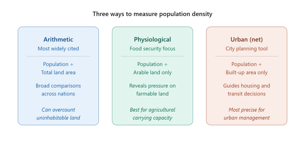
Each measurement type asks a slightly different question. Arithmetic density asks how many people live in a country. Physiological density asks how much pressure those people place on farmable land. Urban density asks how intensely a built environment is being used. Selecting the wrong type for a given policy question produces misleading conclusions.
Why Population Density Outweighs Total Population in Most Policy Contexts
The distinction between population size and population density is not merely academic. It has direct, quantifiable consequences for how governments allocate budgets, how cities are designed, how diseases spread, and how economies develop.
Consider public infrastructure. A government servicing a geographically compact population of 5 million can construct a single regional hospital network, a unified public transit system, and consolidated utility grids at a fraction of the per-capita cost faced by a government servicing the same 5 million people dispersed across a vast rural territory. The World Bank has documented extensively that the unit cost of delivering basic services, water, sanitation, electricity, and healthcare, rises steeply as population density falls. Sparse density is expensive density.
The implications extend into economic productivity as well. A landmark body of research in urban economics, much of it building on the foundational work of economists like Edward Glaeser and his colleagues at Harvard, demonstrates that doubling the density of a metropolitan area is associated with an increase in productivity of between 6% and 28%, depending on the industry and region studied.
This occurs because density generates what economists call agglomeration effects: the clustering of workers, firms, suppliers, and customers in close geographic proximity creates efficiencies and innovation spillovers that dispersed populations simply cannot replicate. Proximity accelerates the exchange of knowledge, reduces logistical friction, and deepens labor markets.
Population Density’s Role in Urban Planning and Housing Policy
Urban planners have long used density metrics as core instruments for shaping land use policy, zoning regulations, and infrastructure investment. The density of a neighborhood determines whether pedestrian-scale amenities are commercially viable, whether a bus route can attract enough ridership to be cost-effective, and whether a grocery store, school, or clinic can serve its catchment area without requiring residents to travel long distances.
Research published in journals including the Journal of Urban Economics and Urban Studies consistently finds that high-density urban environments are associated with lower per-capita transportation emissions, shorter commuting distances, reduced land consumption per household, and greater access to employment markets. Tokyo, often cited as one of the world’s most effectively planned high-density cities, maintains a population density of over 6,000 people per square kilometer across its metropolitan area while sustaining one of the world’s lowest car ownership rates and one of its most efficient public transit systems. Density, in that context, enables sustainability.
The housing policy implications are similarly stark. Cities that resist density through restrictive zoning tend to experience housing cost escalation as population grows faster than the supply of dwellings. The relationship between density restrictions and housing unaffordability has been documented rigorously in cities ranging from San Francisco to Sydney to London, where single-family zoning mandates have effectively capped the housing supply in high-demand urban cores, driving prices to levels that exclude moderate-income residents entirely.
Global Population Density: Key Comparisons by Nation and Region
The global distribution of population density is strikingly uneven. Asia contains roughly 60% of the world’s population across approximately 30% of its land area, producing regional densities that dwarf those of other continents. Africa, by contrast, is significantly less dense overall, though this masks enormous internal variation, from the Saharan north to the densely settled agricultural zones of sub-Saharan West Africa.
The table below compares population density across selected nations, illustrating the range of human settlement patterns globally:
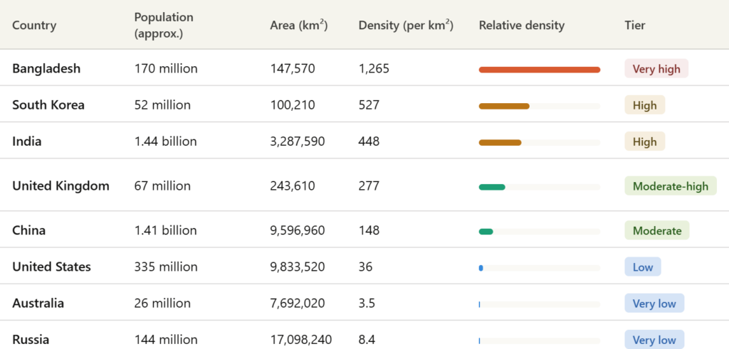
These figures reveal a spectrum that defies any simple relationship between national population size and density. China and the United States are demographically massive yet relatively low-density nations by global standards. Bangladesh, with a fraction of either country’s land area, imposes pressure on its territory that is categorically incomparable. India’s density of 448 per square kilometer, meanwhile, is the backdrop against which the country’s infrastructure gaps, housing shortages, and water scarcity must be understood, not its total headcount in isolation.
Population Density and Public Health: A Critical Relationship
The epidemiological dimension of population density has attracted sustained scientific attention, and with good reason. Dense environments accelerate transmission pathways for airborne and contact-transmitted pathogens. The COVID-19 pandemic provided the most globally visible modern demonstration of this dynamic, with highly urbanized metropolitan areas experiencing initial outbreak severity that correlated strongly with density and transit usage patterns.
Research published in the Lancet and related public health journals has consistently found that urban density, when unaccompanied by adequate sanitation, ventilation standards, and healthcare capacity, becomes a transmission amplifier. The cholera epidemics of 19th-century London and New York were fundamentally density-driven phenomena; disease moved along the same pathways as human contact and shared water infrastructure.
The relationship is not, however, linear or deterministic. Singapore, with a density exceeding 7,900 people per square kilometer, maintains health outcomes that rank among the best in the world, owing to rigorous public health systems, quality housing construction standards, and sustained investment in sanitation and green space. High-density managed well can support population health. High density with inadequate infrastructure is a different matter entirely.
Population Density and Environmental Carrying Capacity
Beyond public health, population density intersects critically with environmental sustainability. The concept of ecological carrying capacity, the maximum population a given ecosystem can sustain without irreversible degradation, depends on density as much as it depends on total population.
High-density regions that consume resources efficiently, as seen in compact European cities, can impose lower per-capita environmental footprints than low-density settlements reliant on private vehicles, sprawling infrastructure, and extensive land clearing. A 2016 analysis from the Lawrence Berkeley National Laboratory found that residents of high-density urban cores in the United States consumed, on average, 40% to 50% less energy per capita for transportation than residents of low-density suburbs in the same metropolitan areas, not because they lived more austerely, but because their built environment made energy-efficient choices structurally easier.
Conversely, when high density concentrates in regions with fragile ecosystems, river deltas, coastal lowlands, and arid zones, the environmental consequences can be severe. Bangladesh’s position in a densely settled river delta makes it acutely vulnerable to flooding, soil salinity intrusion, and displacement driven by sea-level rise. In this context, density is not merely a planning metric. It is a climate vulnerability index.
The Economic Geography of High and Low Density Zones
Economic output is not distributed uniformly across any nation’s territory. It clusters. The concept of economic agglomeration, the tendency for productive activity to concentrate geographically, is one of the most robust findings in spatial economics, and it is inseparable from population density dynamics.
Dense cities are, by nearly every measure, engines of disproportionate economic output. The McKinsey Global Institute estimated in research spanning multiple decades that roughly 600 urban centers, housing less than 20% of the global population, generated over 60% of global GDP at the time of publication. That concentration is not coincidental; it reflects the productivity advantages that density confers through specialization, knowledge sharing, and reduced transaction costs.
Low-density regions, by contrast, face persistent structural challenges. Thin labor markets make it difficult for businesses to find specialized workers. Supply chains extend over longer distances, raising logistics costs. Consumer markets are fragmented. These aren’t arguments against rural economies; they are structural realities that explain persistent urban-rural income gaps observed in economies from the United States to Indonesia to Nigeria.
Closing
Population density is not a secondary statistic filed away behind total population figures. It is, in many respects, the more analytically powerful of the two measures, one that reveals the spatial logic of human settlement, the structural pressures on public systems, the productivity conditions of economies, and the environmental sustainability of the territories people occupy. A nation with a large population can still operate with vast stretches of effectively empty land. A nation with a small population but extreme spatial concentration faces pressures that larger countries may never encounter.
As global urbanization continues, the United Nations projects that nearly 68% of the world’s population will live in urban areas by 2050, up from roughly 55% in 2018. The relevance of density metrics will only intensify. Planners, policymakers, health authorities, and economists who rely solely on total population counts risk misreading the terrain of human settlement entirely. The question of how many people exist matters.
The question of where they exist, and how tightly they are packed together in the places they occupy, matters more. Every meaningful intervention in housing, transit, public health, and climate adaptation ultimately depends not on headcounts, but on the density of the lives behind them.
FAQ Section
1. What is population density in simple terms?
Population density measures how many people live within a specific unit of land area, typically expressed as people per square kilometer or square mile. It shows whether a population is spread out or concentrated, which matters far more than raw population counts when assessing resource availability, service delivery, and living conditions.
2. How is population density calculated?
The basic formula divides the total population of an area by its total land area. For a country with 50 million people and 500,000 square kilometers of land, the arithmetic density would be 100 people per square kilometer. Different types of density calculations, such as physiological density or urban net density, refine this formula for more specific purposes.
3. Why does population density matter more than total population?
Total population tells you how many people exist in a territory, but density reveals how much pressure those people place on land, infrastructure, services, and ecosystems. A country with 10 million people crowded into a narrow coastal strip faces fundamentally different governance, health, and environmental challenges than one with 100 million people distributed across a continental landmass.
4. Which country has the highest population density in the world?
Monaco, a city-state on the Mediterranean coast, consistently ranks as the most densely populated sovereign state on earth, with over 26,000 people per square kilometer. Among larger nations with significant total populations, Bangladesh is consistently ranked among the densest, exceeding 1,200 people per square kilometer.
5. Can a country be large in population but low in density?
Yes, and several of the world’s most populous nations demonstrate this. Russia holds approximately 144 million people, but averages fewer than 9 people per square kilometer due to its vast Siberian territories. Australia, with 26 million people spread across a continent of over 7.6 million square kilometers, registers one of the lowest densities of any populated nation.
6. How does population density affect housing costs?
Dense urban areas with constrained land supply and growing populations experience significant upward pressure on housing prices because more people compete for a limited stock of dwellings. When zoning restrictions prevent vertical or horizontal expansion of housing supply in high-demand cities, scarcity drives prices upward, a pattern documented extensively in cities like San Francisco, London, and Sydney.
7. What is the difference between arithmetic density and physiological density?
Arithmetic density divides the total population by the total land area, including uninhabitable terrain. Physiological density divides the population by the amount of arable, farmable land only, making it a more precise indicator of agricultural carrying capacity and food security risk in regions where large portions of territory are desert, mountain, or otherwise uncultivable.
8. Does high population density always lead to worse health outcomes?
Not necessarily. High density accelerates disease transmission when public health infrastructure is inadequate, but well-governed dense cities like Singapore and Tokyo achieve some of the world’s best health outcomes. The key variable is the quality of sanitation, housing, healthcare access, and urban planning, not density in isolation.
9. How does population density relate to climate change and environmental impact?
High-density urban environments often produce lower per-capita carbon emissions for transportation because residents can walk, cycle, or use efficient public transit rather than relying on private vehicles. However, density in ecologically fragile zones amplifies vulnerability to climate impacts like flooding and drought, as seen in river delta cities facing sea-level rise.
10. How is population density used in urban planning?
Urban planners use density measurements to determine where public transit routes are viable, how many schools or clinics a neighborhood can sustain, how housing supply should respond to demand, and where land use should be zoned for residential, commercial, or mixed uses. Net urban density, which excludes parks, waterbodies, and industrial zones, is the most actionable figure for these decisions.